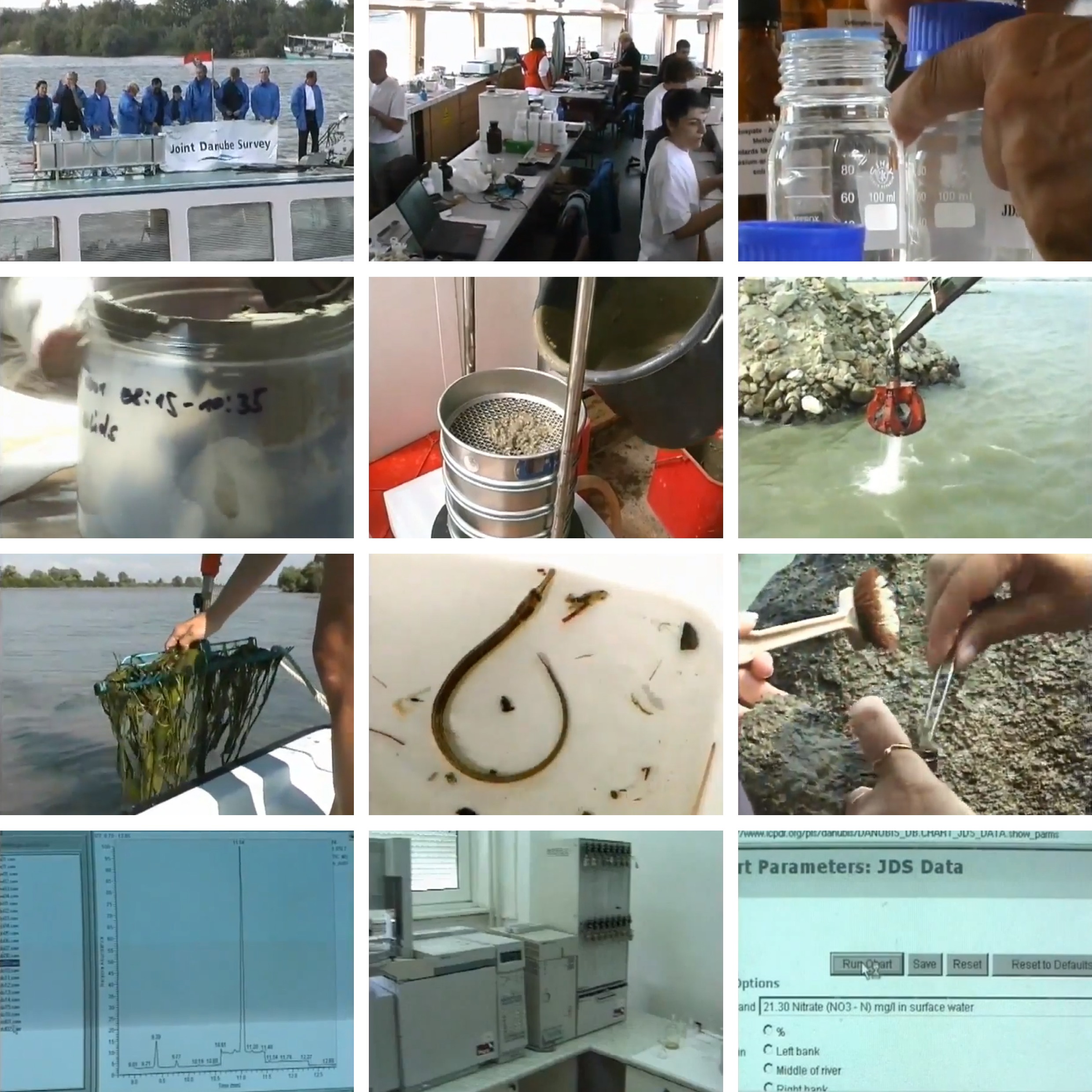
In the summer of 2001, a group of scientists from Germany, Austria, Slovakia, Hungary, Yugoslavia, Bulgaria, and Romania boarded a fleet fully equipped with scientific apparatus and computers. Their goal was to perform a thorough investigation of the Danube Basin on chemical and biological water status in response to the EU’s new water directive. All the data and samples were collected under one uniform standard procedure and analyzed in one single laboratory, which eliminated the possibility of various data interpretation to its maximum, thus constructing a highly comparative database and a comprehensive understanding of the river. The survey had four indices: water quality, suspended solids, sediments and biological samples. Each of them was conducted multiple times in different segments of the Danube River to monitor urban, agricultural and industrial activities’ impact in real-time. Later, all samples were sent to the Austrian Research Center in Vienna for further analysis and archive.
The concept of regarding the Danube Basin as a collective water body across countries was first legislated in 1985’s Bucharest Declaration. So far (2020), ICPDR has formed four joint research teams as a part of a transnational monitoring network. More than merely scientific research, the result of the survey was published by the group and further served as guidelines for policy making that dedicate to maintain the ecological status of the surface water.
← Back to Lexicon
The research institution as a essential part of the trans-national water monitoring network.
Sources: ICPDR, Joint Danube Survey 1 - 2001, 2001, YouTube video screenshot.
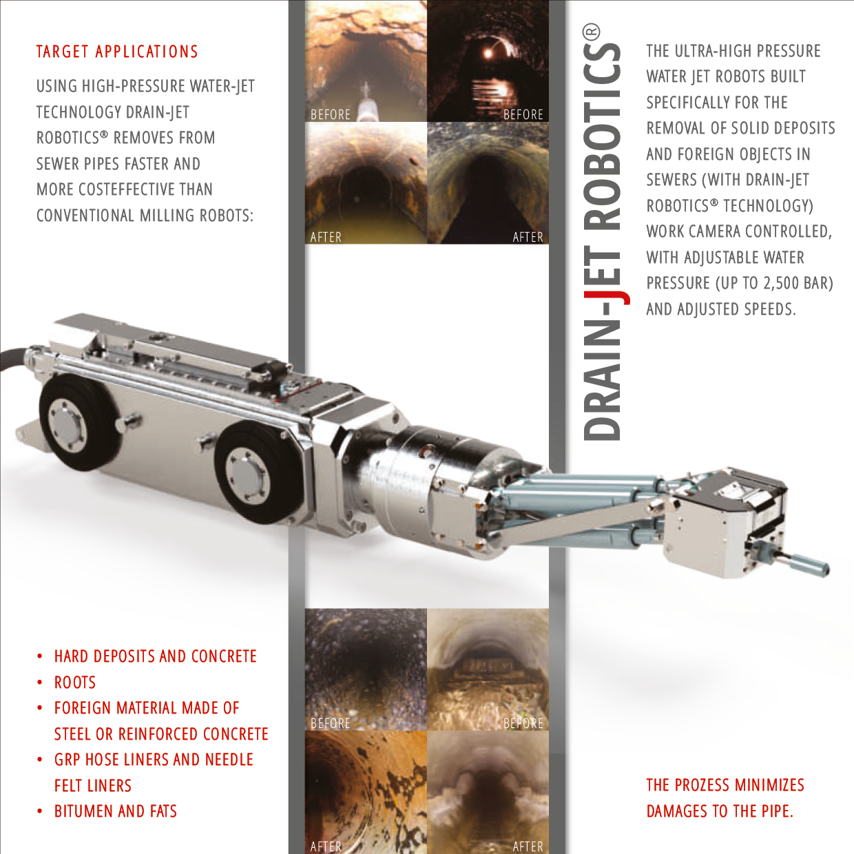
Drain-Jet Robotics
![]()
Urban services are unnoticeable elements of the city unlike new buildings and suburbs development. The sewer municipal system requires constant maintenance to avoid errors and breakages. Being underground it was always a technical question how to clean and repair sewer canals and pipes.
The very first inventions were applied to the Paris sewer system. The Flushing boat was used to move through sewers for manually control and cleaning. The Pills Balls, that were supposed to push and velocity sewer flows, were produced in different sizes as a technical answer for the unreached places of uniform tunnels.The next step in advancing maintenance was self-powered (by engine) equipment that allowed workers to operate overground.1 The further technical improvement, aimed to take workers from manual cleaning and repairing to remote controlling of equipment, came to robotization tools in the end through the automatization and computerization.
Drain-Jet Robotics has high-pressure water serves for cleaning and preparing tunnels and sewer pipelines for their repairs. The video camera allows you to monitor a sewer surface and control a robot in real time, while the data and track recording helps to monitor the sewer tunnels and work operatively and locally. The spot approach of control helps to avoid massive earthworks and optimizes time and resources on fixing breakages and deterioration. Thus Drain-Jet Robotics became a constructor with all additional parts and equipment and a car control room turned into a computer program with navigating robots in a sewer labirint, that is how the real work process of maintaining has turned from tough cleaning to an exciting game.
For proper maintenance sewer lines should be cleaned at least once a year. One Robot with two workers can clean up to 16 Tons KG , from 45 to 100 meters of tunnel in one cleaning session.2 Thus, to clean the municipal sewer system like in Vienna (2400 km), it required 68 robots and 136 workers with everyday cleaning.
← Back to Lexicon
Drain-Jet Robotics advertisement brochure shows one of the latest version of technical cleaning equipment
Sources: https://www.mauerspecht.de/drain-jet-robotics-en.html
Sources: https://www.mauerspecht.de/drain-jet-robotics-en.html
- http://www.sewerhistory.org/photosgraphics/maintenance-sewer-cleaning-equipment/
- https://www.sewerrobotics.com/en/sewer-pipeline-cleaning-and-obstruction-removal/global-pipe-cleaning-and-obstructions-removal-case-studies
Fischer Landfill
![]()
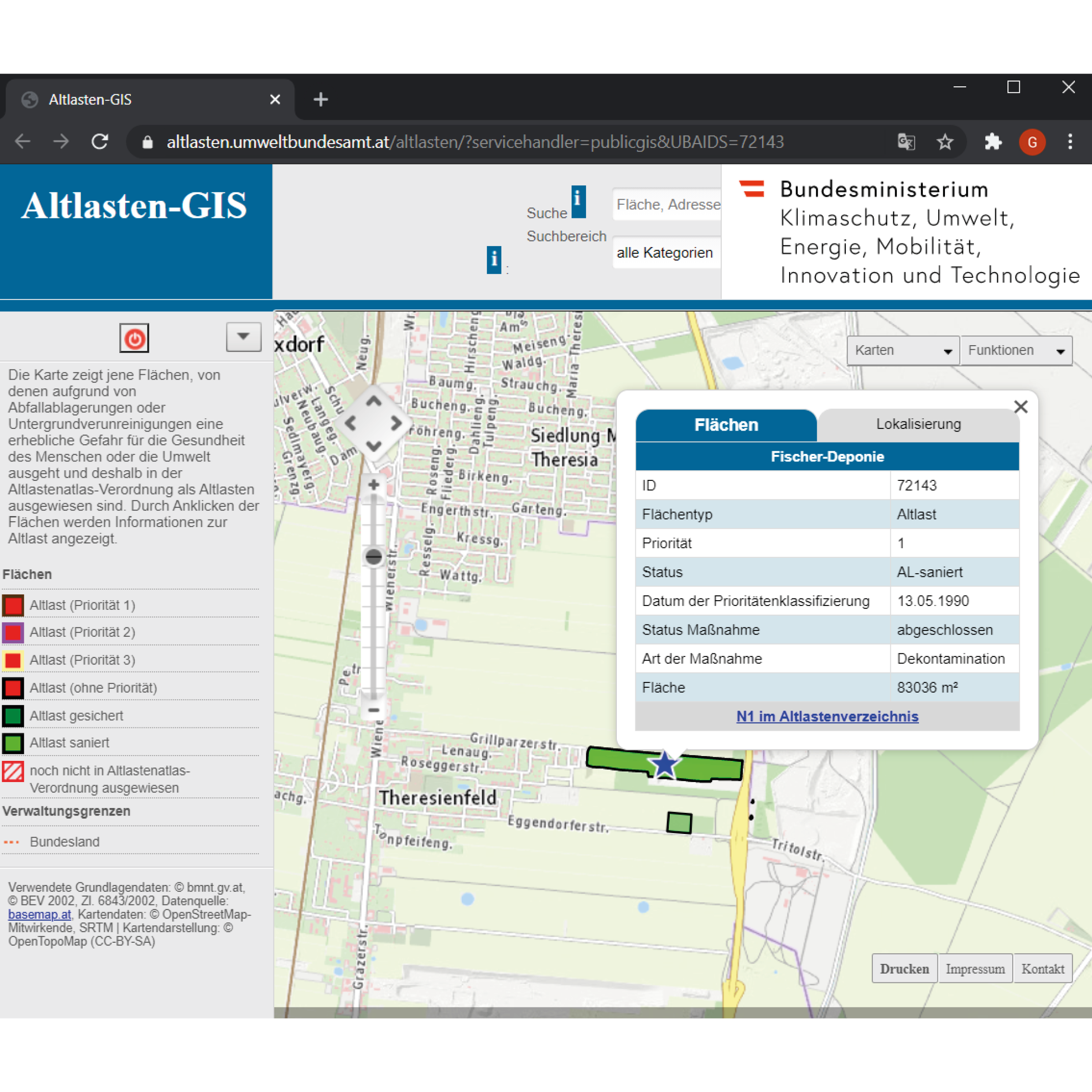
The atlas of the contaminated sites is to provide maps that illustrate the areas of waste deposits or subsurface contamination that threaten either the human health or the environment. Contaminated areas are mapped and listed with their unique ID, priority, status, area, and location. The question now arises: could the contamination be restricted to a limited circumscribed area?
The example of Fischer-Deponie - ID:72143, an area located in the agricultural area of Theresienfeld suggest a paradigm of subsurface contamination but also of groundwater contamination. The landfill was created from a gravel pit in the well drained-bed of the Mitterndorfer Senke, one of the largest reservoirs in Central Europe. However, around 550,000 cubic meters of various types of waste were deposited in an area of around 70,000 square meters without any measures to protect the groundwater. In 1972 the Waxina company deposited poisonous barrels and the latter tenant Johann Fischer, industrial and commercial waste. The operations were taking place from 1972 until 1987, when the authorities managed to enforce the final closure and rehabilitation of the landfill.
Groundwater investigations revealed significantly higher levels of chlorinated hydrocarbons (especially 1,1,1-trichloroethane and trichloroethene) and aromatic hydrocarbons. The massive contamination of the groundwater affected a groundwater body that plays a vital role in the drinking water supply in Easte Austria. Thus, a row of barrage wells was built to treat the extracted groundwater.
The subsoil in the area of the contaminated site is made up of well-drained, Quaternary gravel, which is partially solidified. In the depth of 20 to 25 m, there is a slightly permeable, fine-grained sediment layer, a low-permeability intermediate layer. The groundwater, over the entire length of the dump flows over this layer. The groundwater in the immediate outflow is collected by means of a barrier well and, after cleaning, is drained away again further downstream. A waterworks upstream of the Fischer landfill has been partially shut down due to the supra-regional pollution of the groundwater. The former old deposit is currently not in use.
As a result of the pollution that has already occurred, water supply systems in the area of the Mitterndorfer Basin had to be abandoned. The Fischer landfill, as one of the causes of groundwater pollution, posed an acute threat to a groundwater resource of supraregional importance. The old deposit posed a significant threat to the environment and was to be assessed as a contaminated site in the sense of the ALSAG.
In 2007, after procedures of redevelopment and renovation by the company BALSA GmbH, the Fischer landfill assessed renovated since the remediation foals have been fully achieved and that there are no longer any significant effects on the protected groundwater from the former Fischer landfill and are not expected in the future.
← Back to Lexicon
The atlas of the contaminated sites illustrating the location of Fischer Landfill and the tab of its information.
Sources:https://altlasten.umweltbundesamt.at/altlasten/?servicehandler=publicgis&UBAIDS=72143
Sources:https://altlasten.umweltbundesamt.at/altlasten/?servicehandler=publicgis&UBAIDS=72143
A program dedicated to taking on extremely costly clean up projects resulting from past uses.
The Comprehensive Environmental Response, Compensation, and Liabilities Act of 1980 (CERCLA) was passed by the US federal government to investigate and clean up areas that were contaminated with hazardous substances. The Environmental Protection Agency is in charge of this “Superfund” named by the astronomical costs of cleaning up these sites. Out of 40,000 identified sites federally, 1,600 of them are on the National Priorities List that generally require long-term attention called remedial actions. The ones that require short-term attention are referred to as removal actions.
First, the Superfund tries to bring human exposure to these hazardous substances under control by removal of the contamination as well as through monitoring and control of the area use. For example, by implementing groundwater use restrictions. Once the site is under control, the Superfund then tries to open the site back up by bringing new uses there through redevelopment.
In order to achieve this, the Superfund is in charge of finding the potentially responsible parties. Legally, they have established that the seller of a contaminated site is still responsible for the clean up and that this liability is not something that can be passed onto the buyer. In cases where a potentially responsible party cannot be identified, they receive government funds from taxes which until 1995 was applied to oil companies.
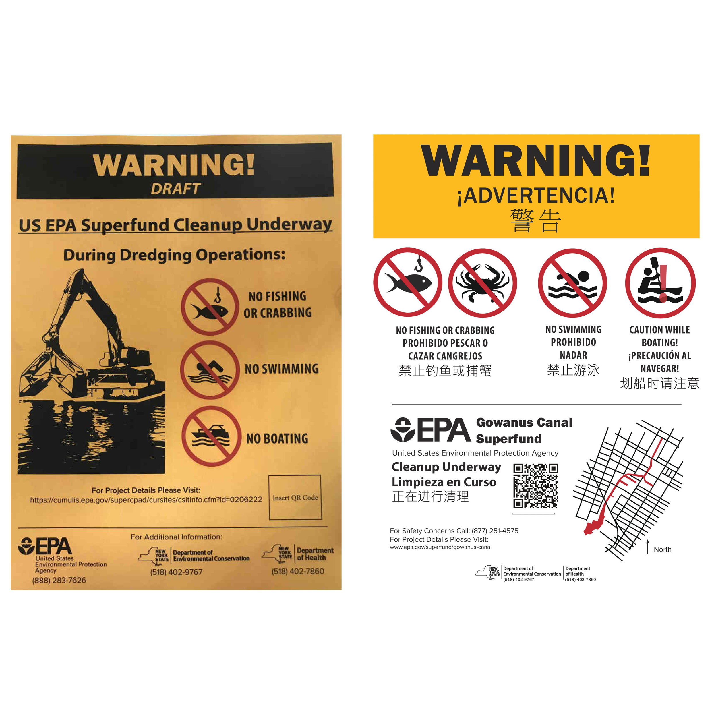
When placing the signs to alert the community around the Gowanus Canal in Brooklyn, NY, of the work being done, the New York State Department of Health was in charge of the project and interfacing with the Gowanus Canal Community Advisory Group. The sign had three drafts before being approved by vote, with one of the changes including a change from “NO BOATING” to “CAUTION WHILE BOATING!” for a group of local recreational canoers.
← Back to Lexicon
Warning sign development with community input for the Gowanus Canal in 2018
Sources: xx
Sources: xx
- https://www.brooklynpaper.com/reel-conundrum-new-signs-ban-fishing-in-toxic-gowanus-but-some-say-they-dont-do-enough-to-discourage-sport/
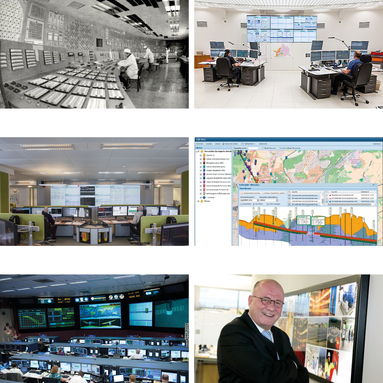
In the control room there is access to the monitoring of the 3,000 kilometers of the municipal water supply infrastructure with the plants and power stations. All parameters can be modified and changed through computerized technology with all necessary technical equipment on different points of the Vienna water and sewer networks.
This technical improvement and upgrade was done according to Water 4.0 strategy. One of the main control parameters is water pollution. The implementation of Water 4.0 technology helps to divide different sewer and storm water flows to optimise the work of sewage treatment plants and the level of drainage.1
The control is implemented with Siemens technology Sinaut ST-7 telecontrol system and the proven Simatic S7-300 controls, the Scada system WinCC OA.2 Kilometers of data cables connects sub-centers in one system, kind of the nervous system of the city that gives and transmit impulses.
The soft support is provided by European Digital Services EDS 4.0 GmbH. It is a private company in Germany that cooperate with municipalities of different cities, espatial Vienna by supplying the technology "Gemeindepaket". They link all urban services through the one date-base platform that digitise and then simplify and optimize administrative tasks and resources.
The concept of Smart City is the integration work and control of different kinds of city infrastructures in real time with possible future prediction and adaptation to changing needs. According to the global smart city index, Singapore, Helsinki and Zurich are the top cities in economical and technological data.3 The importance of optimization of city infrastructures was shown during the Covid-19 era, quick response in extreme situations helps to overcome the economic crisis.
← Back to Lexicon
Chernobyl controlroom, Randstad control room for gas and electricity, Nasa control room, Control room of water infrastructure of Vienna under the Water 4.0 strategy
Sources:
https://press.siemens.com/global/en/news/ifat-2018-hall-a1-booth-439-water-40-new-control-center-vienna-water
Sources:
https://press.siemens.com/global/en/news/ifat-2018-hall-a1-booth-439-water-40-new-control-center-vienna-water
- https://germanwaterpartnership.de/wp-content/uploads/2019/05/GWP_Brochure_Water_4.0.pdf
- https://press.siemens.com/global/en/news/ifat-2018-hall-a1-booth-439-water-40-new-control-center-vienna-water
- https://www.imd.org/smart-city-observatory/smart-city-index/